![]()
OFFSHORE SAILING ROUTE
„A sea will rent each mant new hope, as sleap bring dreams about home"
Cristoforo Colombo
1. DAY Saturday check in 18,00h
2. DAY Sunday 09,00h sailing 35 Nm from marina Rogoznica to the Komiža (island Vis)

The small city of
Komiža also offer a little history. Long time ago
pirates regularly visiting the Komiža town forcing its inhabit
On such a visit of pirates took away a 1,5 m wooden
statue of St. Mary from the small church at western side of Komiža bay. A very
strong wind rose up with high rollers preventing pirates of sailing out the
bay. Few days later when the danger of pirates ceased the islanders found the
statue stranded at Kamenica bay. With great celebration they took the statue
and bringing it back to the original place. They also noticed that spring of
fresh water sprouted where the statue was washed on shore. Happy about this
good news(this spring still exist today) the procession moved St. Mary’s statue
back to the other bays end to find another spring of fresh water shoot up there
too. The islanders used these springs until recently, when the one of them was
covered (sealed) next to the church is named as „Our Lady of Pirate“today.
3. DAY Monday sailing
from Komiža 30 Nm to the island Jabuka and 15 Nm island Svetac (St.Andrija)
08,00 h


Clefts and holes on cliffs of Svetac are choice for a
nest of rare bird species Eleanor’s Falcon. The coast are mostly steep and
rocky with several coves, some of them are home of Mediterranean Mong Seal.
Archeological findings was populated even in prehistory,
island was an import
From the antique time to the 19th century Svetac was
part of „Diomedes navigational route (touched Termiti islands,
Benedictines have left traces on this island, on the
plain Poje are ruins of the monastery and chapel.
Also, legend about Illyrian Quinn Teuta, after she
lost tron, she was banished to this island and has built the castle-fortress
here, counting days of her loneliness.
Island Jabuka stands apart from the otherwise idyllic
Croatian coastal Ares. Due to magnetite that can be found in the black,
volcanic rocks on the island, compasses become completely useless in the vicinity
of this island and only the die-hard visit this place.
Jabuka is not an easy place to visit and really not an
island at all. The shoreline is not suitable for docking; the bays are not
protected from winds. Jabuka is actually a very large, steep, 97 meter high
cliff in the shape of a pyramid.
4. DAY Tuesday 09,00 h sailing
5 Nm from Svetac to the island Brusnik and 12Nm to island Biševo and Blue cave

Brusnik is uninhabited island 320 m long and 205 m wide,
highest point at 30 m above the sea level. Island is made of conglomerates
formed from the fragments of eruptive rocks.

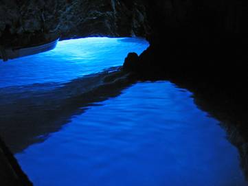
Baron Eugen Rausoonet rediscovered it in 1884.The cave
is 24m long, 10 to 12 m wide, up to 15m high and deep up to 16m at some places.
The entrance is a narrow corridor, which is 1,5m high and 2,5m wide only, being
the only access into the cave itself.
The sun enters into the cove walls in an entire
spectrum of colors with always dominating blue hue. Silvery drops glitter on
brownish limestone walls all over where as the light diffracts in the sea
creating a wondrous silvery glow.
5. DAY Wednesday 06,30
h sailing 40 Nm from Biševo to the Palagruža and 35 Nm to the island Lastovo

Palagruža is small, remote archipelago of dolomite in
the middle of the Adriatic Sea, it consists of one main island, called Vela
(„Great“) Palagruža, and one smaller one, Mala („Little“) Palagruža and there
are twenty or so other closely-associated rocks or reefs.
Vela Palagruža is some 1300 m long and 350 m wide. The
highest point of the archipelago is about 90 m above sea level and on this
elevation is lighthouse. Palagruža is surrounded by dangerous waters. Palagruža
is associated with the Homeric hero Diomedes, king of Argos, who is reputed to
be buried here, thogh it is hard to imagine where.
Speculation is fuelled by the discovery of a painted
6th century B.C. Greek potsherd with the name Diomed.
On March 9, 1177 Pope Alexander III Ship’s convoy set
sail from Apulias small harbor Vieste (Monte Gargano) on Italian Adriatic
northern coast. He was to meet Emperor
Frederic I. Barbarossa at
Sailing with on a good southerner Popes faster
galleons reached island Palagruža when the wind died out forcing the fleet to
the anchor.

Lastovo island in the mids of the Adriatic open sea,
surrounded by numerous small silver islands. An island and archipelago that
like by a miracle escaped the blessings of civilization, maybe the last piece
of the former Mediterranean Homer come and Lord Byron took his inspiration
from.
Lastovo means a vacation in harmony with untouched
nature, a vacation in ambience of traditional architecture.
The name of one of some dozen gardens of
6. DAY 08,00h sailing 33 Nm from island Lastovo to the
island Hvar (Pakleni otoci)
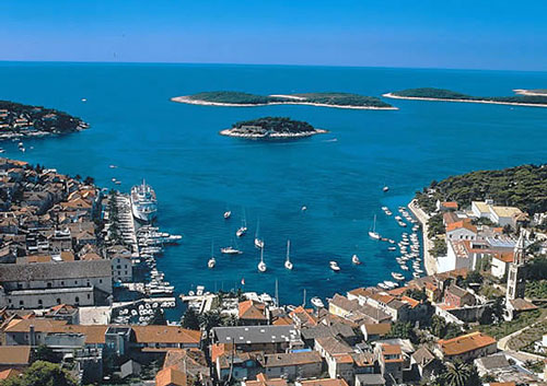

Hvar is a longest and sunniest Croatian island, caracterized
by gentle winters, warm summers and many ours of sunshine.
Island was populated already in the prehistoric times
and later inhabited by the Illyrians, who came into conflict with Greek
Colonizers in the 4th century B.C.
In Oglavak and Koscak (near Sucuraj on the east cape
of island) was the position of the Illyrian Queen Teuta place. Numerous tumuli
on the island are of Illyrian origin.
Hvar accepted the Greek setters, but was the only on
that had an ionic settlement (Pharos, today Stari Grad).
In the 7th century island Hvar came under the
principality of Croatia, in following centuries Hvar recognized the sovereignty
of the Croatian – Hungarian ruler, the Bosnian King Tvrtko, Split Duke Hrvoje,
The Dubrovnik Republic, Venice, France, Austria, Italy etc.
During the 16th and 17th century Hvar was a prominent
centre of the Croatian literature (Petar Hektorovic, Hanibal Lucic).
The town of Hvar with alter towns and
7. DAY 09,00h sailing 22 Nm from
Hvar to the

The largest
The coast is indented, with numerous coves ending with
sand and pebble beaches.
Drvenik Veli was also known in Roman times, under the
name of Tariona. In the 13th century it was mentioned as Giruna or Zerona. The
It houses valuable Baroque furniture and altarpieces
by the Venetian painter Antonio Grapinelli.